One herring, two herring
Counting fish is difficult. But in the future laser technology may make the task fast and efficient.
Today, the size of Norwegian fish stocks is estimated with the help of sound devices such as echo sounders and sonars installed in large research vessels. These measuring techniques are steadily improving, but are costly and time-consuming. Alternative methods, using aeroplanes and lidar technology are now under evaluation.
Lidar (light detection and ranging) is a kind of radar that makes use of laser light instead of radio waves. If you’ve ever been caught speeding, you may have already encountered lidar: the laser meter used by the police is a lidar, but it is not as advanced as the one now being developed by scientists at NTNU and the Institute of Marine Research.
MILITARY ORIGINS
Lidar technology was originally developed by the American armed forces to detect foreign submarines. Professor Jens Hjelmstad and PhD student Eirik Tenningen at NTNU have been working for two years to develop the technology and related methods to help fisheries researchers and managers survey fish stocks in various areas.
This is crucial to allow sound management of the world’s fisheries. Mackerel and herring are particularly difficult to count because they are a type of fish that swim in schools in the upper layers of the ocean. They are easily scared off by ships, and counting the fish is further complicated by the fact that echo sounders only register fish 10 to 12 meters below the ship’s own position. In contrast, planes don’t frighten fish away, and the lidar is able to survey everything from the ocean surface down to depths of 40 to 50 meters.
AFFORDABLE AND EFFECTIVE
During cruises last summer, the lidar only registered whether or not there were fish and whether they were in large or small quantities. The aim is to be able to distinguish one fish from another, as well as to determine fish type, but these results lie just over the horizon, researchers say.
“We will need about three or four more years,” estimates professor Hjelmstad. Nevertheless, the method is already far quicker and more affordable than current methods. In just 30 hours, a plane can cover an area that two ships take two weeks to map. The estimated cost is a tenth of what the operation costs today.
3D
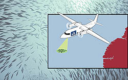
The lidar laser is mounted in the belly of a plane that flies at an altitude of just 300 meters above the ocean’s surface. Every second, thirty pulses of green or blue-green light are shot into the water. Blue-green light is the colour that penetrates the deepest before it is filtered out. When the light hits the water, it is reflected back to a receiver in the plane. The information that is returned is projected as images onto a system of co-ordinates, with the depth and extent on the two axes corresponding with echograms in acoustics. Fish are projected as small lines.
The closer together the lines, the more fish there are. By using a greater number of colour frequencies and receivers, the image will be able to provide information about the type of fish the light hits: different kinds of fish reflect light differently. The aim is to make 3D images that accurately determine the amount and type of fish. Once this level of resolution has been achieved, the technology could also be applied to other fields of research, such as detecting oil pollution and constructing topographical maps of the ocean floor.
Christian Fossen


